History
Top 10 Oldest Buildings In The World (*Terrifying*)

The world’s oldest structures give information on the origins of civilization. They also help us comprehend human cognition in the past and how it has evolved. Constructing buildings in ancient times was a very tough task as there was no transportation and the crafting of materials as well as procuring them was a hectic process. This list sheds light on the oldest structures ever built in the world.
Here are the top 10 oldest buildings in the world.
Göbekli Tepe
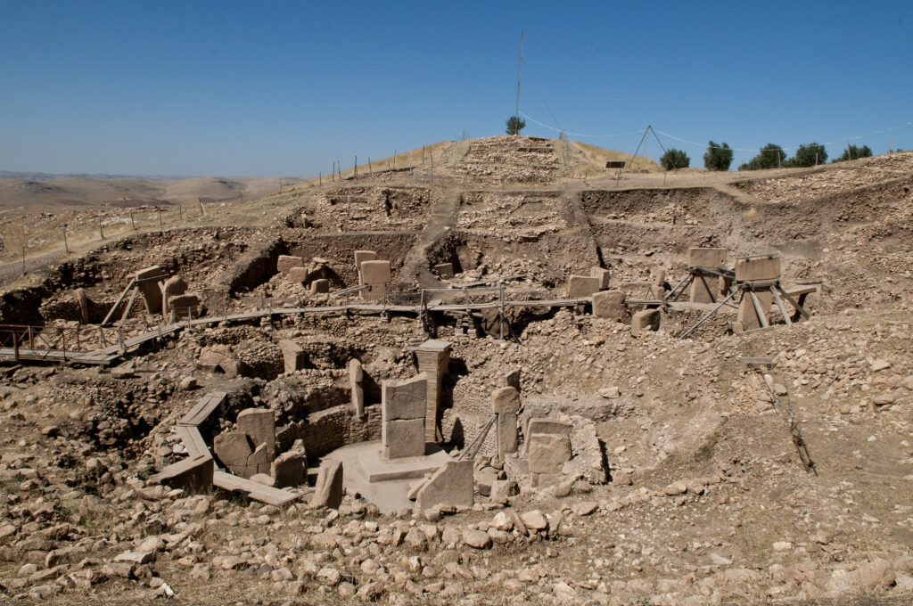
Göbekli Tepe
Göbekli Tepe, also known as Girê Mirazan or Xirabreşkê, is a Neolithic archaeological site in Southeastern Anatolia, Turkey, near the city of Anlurfa. [Source: Wiki]
The site, which dates to the Pre-Pottery Neolithic period, between about 9500 and 8000 BCE, consists of a collection of huge circular buildings supported by massive stone pillars — the world’s earliest known megaliths.
Many of these pillars are highly painted with abstract human characteristics, clothes, and reliefs of wild animals, offering archaeologists rare insights into prehistoric religion and iconography. It is situated in southern Turkey. The tell has two eras of usage, which site discoverer and excavator Klaus Schmidt believes date back to the 10th–8th millennia BCE and are of a social or ceremonial character. The structure is 300 m in diameter and 15 m high.
Tower of Jericho

Tower of Jericho
The Tower of Jericho is a 28-foot-tall stone tower erected circa 8000 BCE during the Pre-Pottery Neolithic A era. It is one of humanity’s first stone monuments.
John Garstang uncovered the Wall of Jericho during excavations from 1930 to 1936, which he thought were those recorded in the Book of Joshua in the Bible and dated to approximately 1400 BCE. Kathleen Kenyon found the tower erected against the town wall during excavations in the trench I between 1952 and 1958.
Kenyon offered evidence that these structures were part of an early proto-city and dated far older, to the Neolithic, the most recent period of the Stone Age. The tower emphasizes the significance of Jericho in understanding settlement patterns during the Sultanian period in the Southern Levant.
Mehrgarh
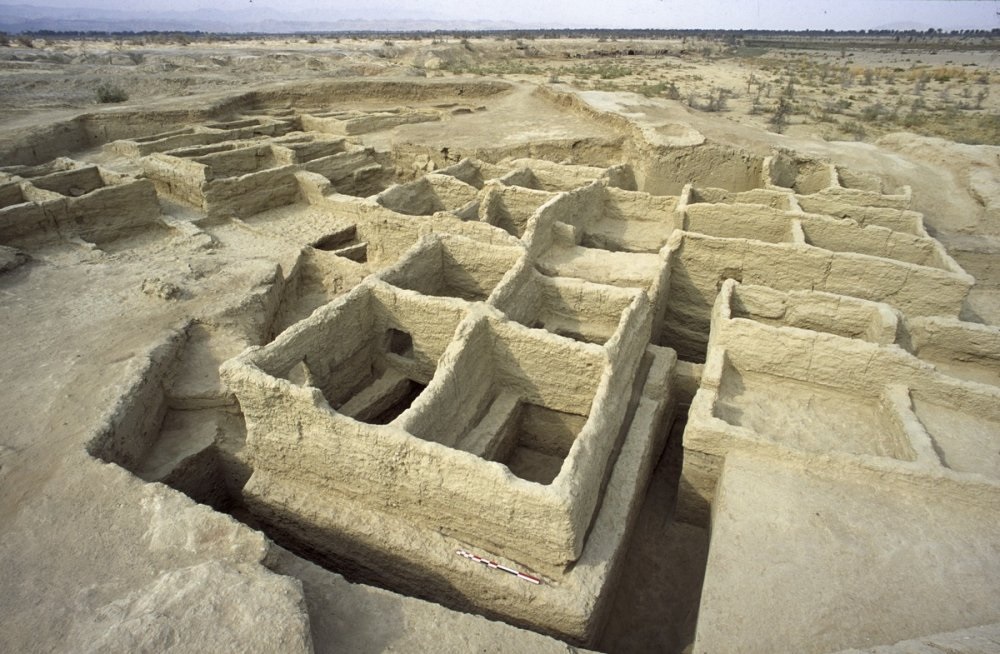
Mehrgarh
Mehrgarh is a Neolithic archaeological site in Pakistan that dates from around 7000 BCE to around 2500/2000 BCE and is located in the Kacchi Plain of Balochistan. It lies near the Bolan Pass, west of the Indus River, and between the contemporary Pakistani towns of Quetta, Kalat, and Sibi.
An archaeological team led by French researchers Jean-François Jarrige and his wife, Catherine Jarrige, found the site in 1974. Between 1974 and 1986, and again from 1997 to 2000, Mehrgarh was excavated constantly.
Archaeological material was discovered in six mounds, and around 32,000 objects were gathered from the site. The first community at Mehrgarh was a modest agricultural village that existed between 7000 and 5500 BCE and was located in the northeast corner of the 495-acre site.
Barnenez
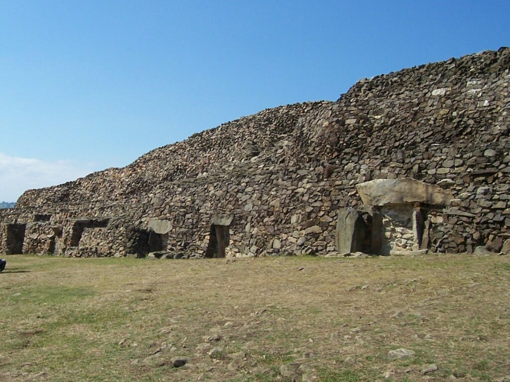
Barnenez
The Cairn of Barnenez is a Neolithic monument in northern Finistère, Brittany, near Plouezoc’h on the Kernéléhen peninsula (France). It is from the early Neolithic period, around 4800 BC. It is one of Europe’s earliest megalithic monuments, along with the Tumulus of Bougon and Locmariaquer megaliths in Great West France, and one of the world’s oldest man-made structures.
It’s also noteworthy for the existence of megalithic art. It is located in northern Finistère and has been largely repaired. It should have been called ‘The Prehistoric Parthenon,’ according to André Malraux. The construction is 72 meters (236 feet) long, 25 meters (82 feet) broad, and more than 8 meters (26 feet) tall.
Tumulus of Bougon
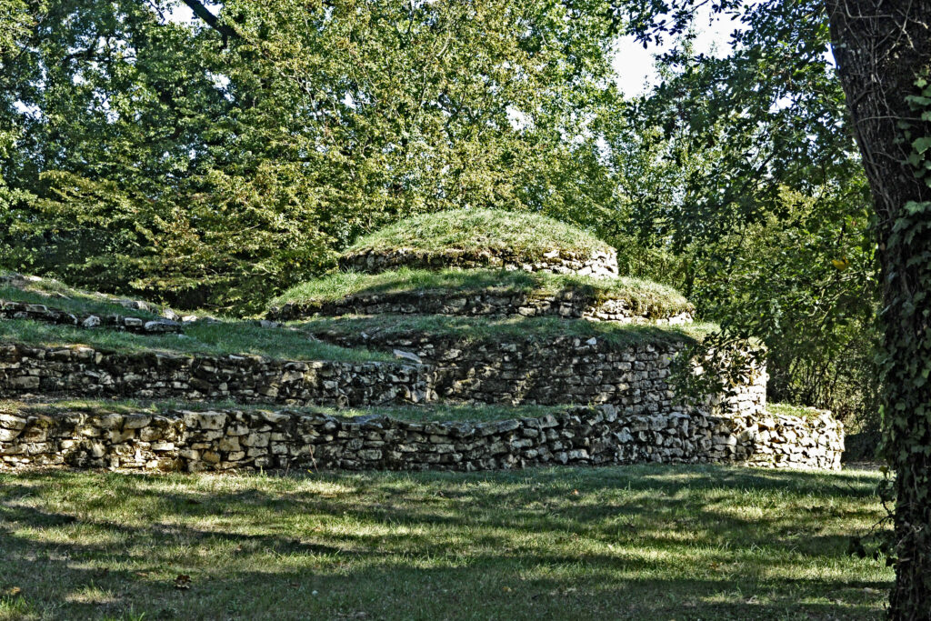
Tumulus of Bougon
The Tumulus of Bougon, also known as the Necropolis of Bougon, is a collection of five Neolithic barrows found in Bougon, between Exoudon and Pamproux in Nouvelle-Aquitaine, France.
Their discovery in 1840 piqued the scientific community’s curiosity. In order to conserve the antiquities, the department of Deux-Sèvres purchased the land in 1873. In the late 1960s, excavations were restarted. This ancient monument’s earliest constructions date back to 4800 BC.
Saint-Michel Tumulus
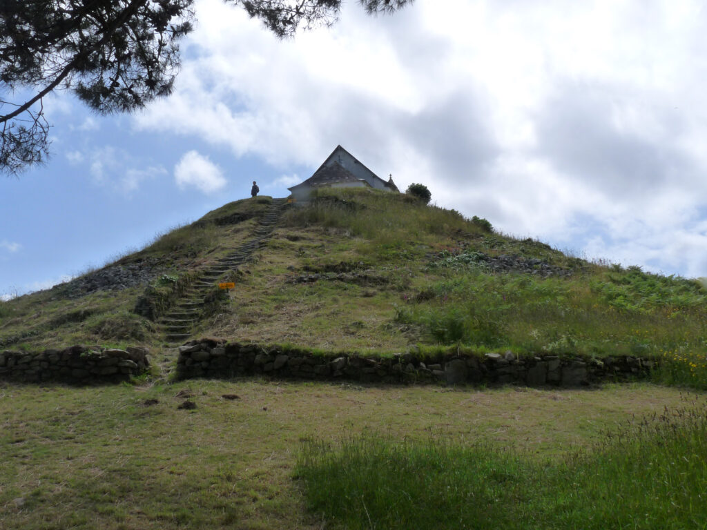
Saint-Michel Tumulus
The tumulus was constructed around the fifth millennium BC.
The Saint-Michel tumulus is a 125-meter (410-foot) long, 50-metre (160-foot) broad, and 10-meter (33-foot) high earth and stone mound. In 1862, archaeologists discovered a central vault holding distinguished burial furnishings such as axes, pearls, flint tools, and sillimanite.
Since 1889, it has been designated as a “Monument Historique” (national historic site).
Around 1900, archaeologist Zacharie Le Rouzic dug the Saint-Michel tumulus again and unearthed a second dolmen and fifteen small stone boxes, revealing the monument’s complexity.
Read More: Top 10 largest countries in the world
Uruk

Uruk
Uruk, also known as Warka or Warkah, was an ancient Sumerian city located east of the current course of the Euphrates River on the dried-up old Euphrates channel 30 kilometers (19 miles) east of modern Samawah, Al-Muthanna, Iraq.
Uruk is the Uruk period’s type site. Uruk was a key figure in Sumer’s early urbanization in the mid-4th millennium BC. By the end of the Uruk period, about 3100 BC, the city may have had 40,000 citizens, with 80,000-90,000 people living in its surroundings, making it the world’s biggest urban area at the time.
According to the Sumerian King List chronology, the mythical king Gilgamesh reigned Uruk in the 27th century BC. The city fell out of favor in the context of Babylonia’s war against Elam circa 2000 BC, although it remained inhabited during the Seleucid (312–63 BC) and Parthian (227 BC to 224 AD) eras until it was eventually abandoned sometime before or after the Islamic invasion of 633–638.
William Kennett Loftus visited Uruk in 1849 and identified it as “Erech,” also known as “the second city of Nimrod,” and oversaw the initial excavations from 1850 to 1854.
Read More: Top 10 tallest buildings in the world
Monte d’Accoddi
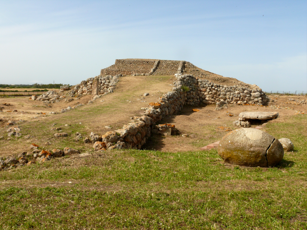
Monte d’Accoddi
Monte d’Accoddi is a Neolithic archaeological site in northern Sardinia, in the Sassari area. The site consists of a huge elevated stone platform that was formerly supposed to be an altar. It was built by the Ozieri civilization or earlier, with the earliest pieces dating back to roughly 4,000–3,650 BC.
The site was discovered in 1954 on a Segni family property. The original building, which had a base of 27 m by 27 m and presumably reached a height of 5.5 m, was created by the Ozieri civilization or earlier about 4,000–3,650 BC.
It culminated in a platform of 12.5 m by 7.2 m in size, accessible by a ramp. Because no chambers or entrances to the mound have been discovered, it is assumed that it was an altar, temple, or step pyramid. Because its square plan corresponds to the cardinal points of the compass, it might have also acted as an observing device.
Read More: Top 10 historical places in India
La Hougue Bie

La Hougue Bie
La Hougue Bie is a historic site in the parish of Grouville, Jersey, including a museum. The image of La Hougue Bie is on the Jersey 1 pound note issued in 2010.
The site consists of a tunnel chamber 18.6 meters long and a 12.2-meter high earth mound. The Société Jersiaise explored the site for the first time in 1925. Fragments of twenty vase supports were discovered, as well as the dispersed remains of at least eight people. Grave goods, primarily ceramics, were also on display.
La Hougue Bie is a Neolithic ceremonial site that was active between 4000 and 3500 BC. It is one of the largest and best-maintained passage tombs in Western Europe, as well as the most spectacular and well-preserved monument of the Armorican Passage Grave group.
Two medieval chapels, one from the 12th century and one from the 16th century, stand atop the hill. This building complex has seen several changes during its history, including being swallowed for a time by the Prince’s Tower.
During WWII, it served as a major lookout point, and an underground command bunker was erected in the mound and neighboring areas.
This building is available to the public and holds an exhibition honoring the workers from all over Europe who were compelled to build Jersey’s defenses during the German occupation.
Knap of Howar
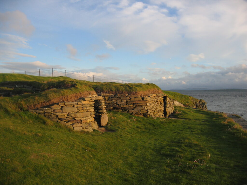
Knap of Howar
The Knap of Howar, located on the Orkney island of Papa Westray, is a Neolithic farmhouse that may be the earliest remaining stone building in Northern Europe. Radiocarbon dating indicates that it was occupied from 3700 BC to 2800 BC, which is earlier than the identical dwellings at the Skara Brae settlement on the Orkney Mainland.
The farmhouse is made up of two adjacent rounded rectangular thick-walled structures with extremely low doors facing the sea. A low hallway connects the bigger and older structure to the smaller building, which has been interpreted as a workshop or a second dwelling.
The walls are still standing to an eaves height of 1.6 meters (5 ft 3 in), and the stone furniture is still in place, creating a realistic image of life in the home. Fireplaces, partition screens, beds, and storage shelves are mostly undamaged and post holes suggest the roof structure have been discovered.
The evidence from the middens indicates that the occupants kept cattle, sheep, and pigs, cultivated barley and wheat, gathered shellfish, and fished for species that must be line caught using boats.


